Goodnight Raleigh - a look at the art, architecture, history, and people of the city at night

The Abandoned Section Of Stanhope Avenue


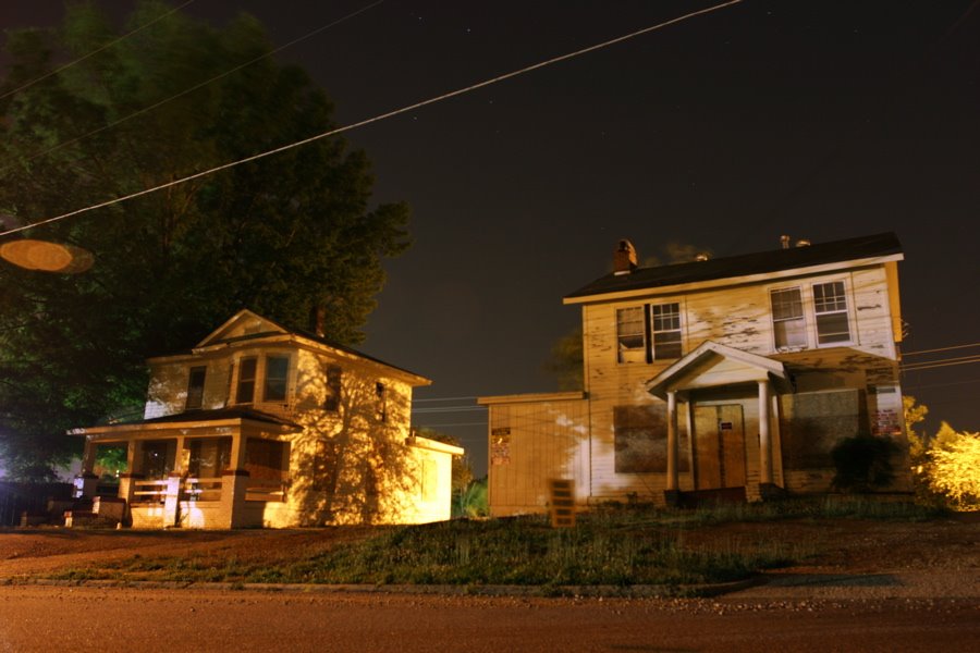
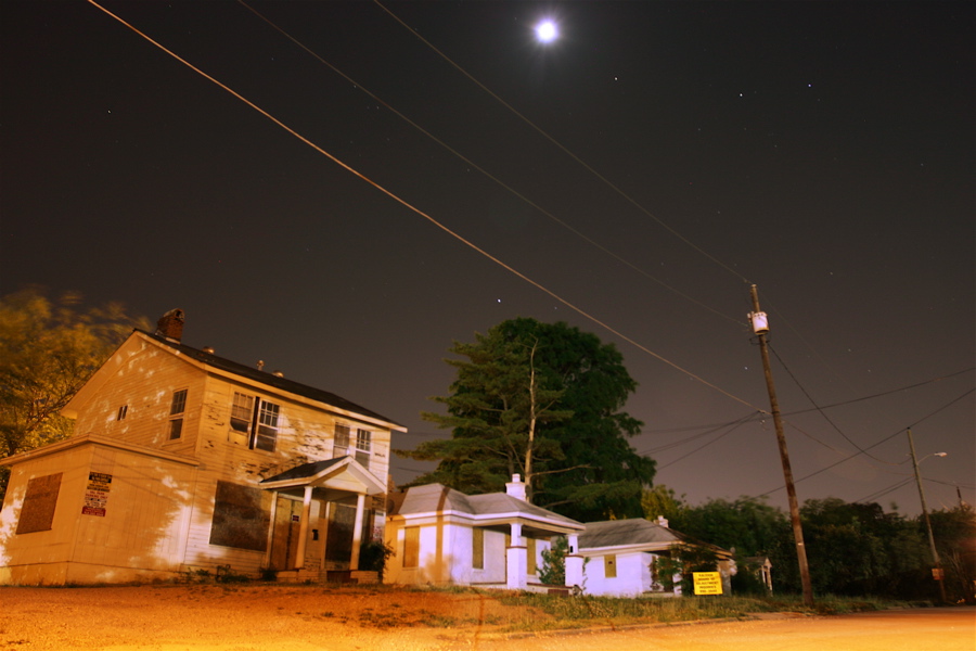
There is a section behind the old bulldozer building on Stanhope Avenue that has been abandoned for a few years now. Ballentine Properties has been renting out the space for student parking in recent years. Stanhope is one of those parts of Raleigh that are somewhat hidden, as you usually only wind up there out of curiosity or by accident. It’s a series of older and mostly modest homes that have been there for some time.
When I stopped to get these pics, I talked to a resident of the road and got a good bit of the sentiment that prevails amongst some of the residents. For the interest of disclosure, I am employed by Lulu.com which will soon be moving into the NC Equipment Building (aka The Bulldozer Building) that makes up a good part of the landscape on Stanhope Ave. From what I understand, they (my employer) are anxious to see the Stanhope Plan come to fruition. Although the resident I spoke with didn’t outright state opposition to the Stanhope Plan, I got the impression that the residents of the street were not enthusiastic about it. I’m not sure if it is because of plans for student housing or parking, or the increased amount of traffic which it would bring to the road, or something else. In any event, I can certainly understand the apprehension of new development in one’s backyard. The extremely rural area where I grew up is transforming from apple orchards and logging trails in to housing developments and state parks. It’s not easy to see the environment you’ve come to know change in ways beyond your control.
The person I spoke with went to NC State, and has memories of people and friends that lived in the houses pictured above. She said that the last memories she has of people living there were those of a shady nature, being associated with drug dealing and other nefarious activities.
So the question remains, what is the best way forward? I can’t say I have the answer. Although I have a great passion for historic preservation, sometimes development comes and you are powerless to stop it.
It appears that the bone of contention isn’t that these old and decrepit houses are getting knocked down, but what will appear in their place–that which is more friendly to students, or something that is more friendly to long term residents.

View Larger Map

The History Of The Hillsboro[ugh] St. Name

Pictured above is the only example (that I’m aware of) that uses the the particular spelling of Hillsborough Street without the ‘ugh’.  The only other place I’ve seen this spelling was on the famous bird’s eye view map of Raleigh in 1872.

According to a historical account [PDF] by the Hillsborough Historical Society, the evolution of the spelling of the city of Hillsborough influenced the spelling of the familiar street in Raleigh:

When originally founded in 1754 as the seat of Orange County, the town merely had the name of Orange. It was quickly changed to Corbin Town, and then again to Childsburg (or Childsburgh). In 1766 the town was renamed Hillsborough, in honor of Irishman Wills Hill, the Earl of Hillsborough. Four years later, the use of the term “borough’ was strengthened when the town was made an official English pocket borough.

This designation gave the town a vote in the North Carolina Colonial House of Commons. It also recognized the town’s stature in Colonial political life, and probably aided in its being used as the meeting place of the North Carolina General Assembly several times before the establishment of Raleigh as the capital in 1792.

As early as 1800, the name had been shortened to Hillsboro’ and then to Hillsboro. By the middle of the century the Hillsboro spelling was widely recognized as the “official” spelling of the town’s name, though no documents in the town or state government record a name change. Every official building in town from Hillsboro High School to the Hillsboro post office used the shortened spelling in 1962, when the Society was formed.

The Hillsborough Historical Society was an exception to this rule and an early herald of the return of the original 1766 spelling. When the Society was formed in March 1962, the spelling of Hillsborough with the ‘ugh’ was used. It made sense for the organization, which took on the challenge of preserving the history of the town, to take on the original spelling.

At the same time, others interested in returning the ‘ugh’ began working to accomplish this. In December 1962, the Society newsletter included a report that town postmistress Louise R. Clayton had petitioned postal authorities to return the “proper spelling” of Hillsborough to the post office and the postal stamp.

Within 13 months, other groups began using the ‘ugh’ spelling, at the urging of the Society. These included the News of Orange County and the Hillsborough Lions Club, who also updated their road signs.

The July 1965 [Hillsborough Historical Society] newsletter joyously announced the news that
“THE HILLSBOROUGH SPELLING, reaffirmed on May 4, 1965, by a special bill passed by the General Assembly, will soon be seen everywhere.

The Highway Dept. states that it has made estimates and is now proceeding with new State Highway markers to replace all “Hillsboro” ones. Postmaster Louise Clayton has applied for a new cancellation die and this should come before long. The town of Chapel Hill voted to change the spelling of “Hillsboro” Street to Hillsborough Street and the new signs are already in place.

Durham and Raleigh are considering similar changes. Newspapers in the area made the change promptly. By the end of the year the Hillsborough spelling should be in general usage.

After almost one hundred years of Raleigh’s most famous street being spelled ‘Hillsboro’, it was changed to ‘Hillsborough’ in the mid 1960s due to the hard work of a postmistress and a historical society many miles away.

Raleigh National Cemetery

The Raleigh National Cemetery was created in 1865. The Veterans Administration [PDF] says that

Located in a neigh­borhood of mixed residential and commercial develop­ment, the cemetery is a nearly seven-acre, largely flat, grassy rectangle on a north-south axis. The main entrance is off the west boundary defined by Rock Quarry Road, and is located in the northwest quadrant of the acreage that is further defined by an enclosing brick wall erected circa 1875.

The site of the national cemetery was originally designated as “Camp Green,” an army post used as headquarters of the occupation forces stationed in the Raleigh area [during the Civil War]. This is evi­denced by the establishment of a “post” cemetery, wherein a total of 32 burials were made of troops and members of their families. The post cemetery is now Section 10 of the Raleigh National Cemetery.

View Larger Map


Discuss Raleigh

  • Recent Comments:


  •