
Raleigh At Four Hundred Acres
A plate near the sidewalk at the corner of East St and New Bern Avenue reads:
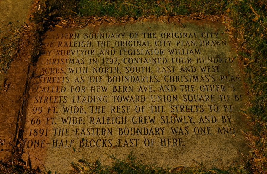
Eastern boundary of the original city of Raleigh. The original city plan, drawn by surveyor and legislator William Christmas in 1792 contained four hundred acres with North, South, East, and West Streets as the boundaries. Christmas’s plan called for New Bern Ave and the other streets leading towards Union Square to be 99 ft. wide, the rest of the streets to be 66 ft. wide. Raleigh grew slowly, and by 1891 the eastern boundary was one and one-half blocks east of here.
Raleigh Boy noted these original boundaries when commenting on the history of the Hillsboro(ugh) St. name.
 Like us on Facebook
 Follow us on Twitter
 Subscribe to RSS feed
 Subscribe to posts by Email
 Sign up for the Newsletter
05/23/2008
Regarding the sidewalk markers along New Bern Ave: this is from a contributor on the Urban Planet History of the Triangle Blog:
http://www.urbanplanet.org/forums/History-Triangle-t19040.html&st=160
“The New Bern markers are on both sides of the street. Driving by, you would never know they are there. With the trash and overgrowth (which I’ve cleaned several times during neighborhood cleanups) you could walk right over them without noticing. From memory, there is a plaque near the Federal Building about the old high school [i.e. Hugh Morson, described in a post below–R.B] and tablets at
– New Bern/Bloodworth (NW by the dry cleaner?)
– SE New Bern/East mentions former granite quarry nearby to the south where the material for the Capitol and some tombstones in City Cemetary came from
– NW New Bern/Swain (mentions Hungry Neck [a former freedmen’s settlement from Reconstruction days. There’s one or two original houses still standing, the rest are much newer–R.B] area from Swain/Edenton to St. Augs)
– SE (possibly SW) New Bern/Tarboro
There might be others in between, but it has been a while.”
05/23/2008
It’s a good reminder of how originally, Raleigh was a very well-planned city. All the streets neatly laid-out, in an easy-to-understand north/west/south/east grid. The higher the address number, the further from the capital building. Very good design.
Unfortunately it didn’t last long. The railroad broke up many streets, and then the use of the automobile added sprawl and such and Raleigh stopped building its streets on a strict grid pattern. Shame.
05/24/2008
raleigh boy –
about the part of trash and overgrowth, if you look at the left side of the marker you’ll notice it has a distinctly brown color not visible on the rest. This was because it was covered with dirt and debris before I took the photo. I knew about the one near New Bern/ Tarboro, because it’s going to be in a future post! I’ll be sure to check the others out
raleighrob – That’s a very interesting tidbit about the address in relation to the capitol building. I am curious as to how the railroads broke up the roads. Something else to look in to, maybe for a future post…
05/27/2008
John,
Yes it’s Rob. :-)
Yeah, the capital actually creates an X-axis for addresses, with Hillsborough/NewBern/Halifax/Fayetteville Streets creating the major directions. All other streets have a N/S/W/E designation. (East Hargett, North Sailsbury, etc)
So…for addresses the blocks are times ten. Example: 500 West Morgan means you are 5 blocks west of the capital axis. Makes things real simple.
As far as streets being broke off by the railroad there’s several. Lane and North are the two most folks know of.
Another one got so distantly separated that they went ahead and just changed the name. What we know as Glenwood Ave today, before the railroad, was called “North Saunders Street”. :-)
10/13/2009
Good Info!